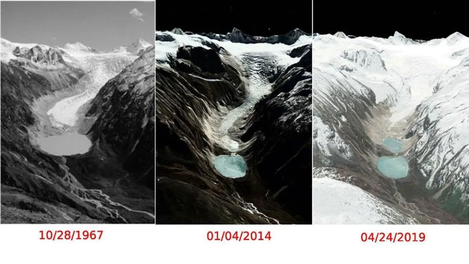
Arya News - Preliminary satellite analysis indicates an upper-lake outburst triggered the Sintaphu Lakes GLOF in Laya, causing downstream flooding.
THIMPHU – The glacial lake outburst flood (GLOF) from the two Sintaphu Lakes in Laya, Gasa appears to have been triggered by an outburst from the upper lake, which may have caused water to flow into the lower lake and subsequently contributed to the downstream flooding, according to a preliminary analysis of available satellite data.
Sintaphu is a high-altitude glacial lake near Wakila Mountain in Lungo, Laya. Located at the headwaters of the Mo Chhu, it comprises two separate glacial lakes: an upper lake and a lower lake. It is among Bhutan’s 17 potentially dangerous glacial lakes.
Specialists studied the lake between May and June 2023, examining the main and upper lakes, surrounding terrain, moraine barriers and the glacier feeding the lakes.
The two lakes are located near the glacier snout. The larger lower lake covers approximately 23.53 hectares, while the smaller upper lake spans about eight hectares.
According to the National Centre for Hydrology and Meteorology (NCHM), the lower lake has a larger water volume than the upper lake.
The satellite data analysis suggests that both the upper and lower lakes experienced significant changes during the event, with the lower lake recording the most substantial reduction in surface area. However, further assessment is needed to establish the exact sequence of events and confirm how the two lakes contributed to the flood.
The two lakes have released an estimated 4.89 million cubic metres, but still hold approximately 3.19 million cubic metres. Satellite images also suggest that the upper lake is refilling.
According to the International Centre for Integrated Mountain Development (ICIMOD), the lake held an estimated 6–7 million cubic metres of water before the outburst, enough to fill about 2,400–2,800 Olympic-sized swimming pools.
The outburst may have reduced one aspect of the GLOF risk by releasing a substantial volume of water from the Sintaphu lakes. However, it would be premature to conclude that the overall risk has declined. The danger may have shifted rather than disappeared.
Satellite images acquired on October 31 and November 1 indicate that the upper lake appears to be refilling. However, satellite findings need to be verified through a physical field assessment.
There are already reasons for concern. The assessment shows that the lower lake experienced the most significant changes, with its mapped surface area decreasing by 73.03 percent and its water volume declining by 81.53 percent.
The lower lake’s water level is estimated to have dropped by 28 metres, from 53.2 metres before the event to 25.2 metres after the outburst.
The upper lake also experienced a reduction, with its mapped area decreasing by 9.55 percent and its water volume declining by 5.39 percent. Its estimated water level fell by approximately 0.4 metres, from 44.9 metres to 44.5 metres.
The analysis estimates that a combined lake area of 186,284.17 square metres was lost during the event, including 171,131.67 square metres from the lower lake and 15,152.51 square metres from the upper lake.
A substantial volume of water remains in the upper lake, and its potential threat is not yet clear.
The outburst has created a new artificial lake near Taktse Makha, formed by debris blocking a river channel. If this natural debris dam becomes unstable or breaches, it could trigger another flood downstream.
However, as of November 2, the water has been flowing in a normal phase according to Gasa Dzongda Jigme Namgyel.
NCHM did not receive any prior information or warning indicating a rise in water levels in the Sintaphu lakes. Unlike the glacial lakes in Lunana, Sintaphu has no water-level monitoring sensors installed. The nearest NCHM monitoring station is at Tatshe Makha, which limits the agency’s ability to monitor changes in water levels in the lakes in real time.
GLOF damage roads, bridges, livestock and public infrastructure
The preliminary economic losses is estimated at Nu 6.8 million, according to the Department of Livestock.
The flood washed away Gasa Tshachu, one of the popular natural hot spring destinations in the country.
This is the second time a major flood has washed away facilities at the hot spring in five years. On August 26, 2021, a flash flood swept away all seven ponds, bridges, and several concrete structures at the Tshachu. Earlier, in May 2009, another flood destroyed the hot spring basin, an outreach clinic and an adjoining room.
The Laya Gewog Centre Road was badly damaged by, with three major sections between Koina and Tongchudra blocked and the Tongchudra bridge completely washed away.
The road formation at three locations between Koina and Tongchudra was severely damaged, with sections washed away from their foundations. The damage is worst at Tongchudra, where the entire road base, including the stretch beyond the bridge towards Laya, has been swept away.
The Sintaphu Lake outburst killed at least 128 yaks and 12 horses, and some 10 yaks still missing and one injured. The number of dead and missing yaks is likely to rise once verification is complete.
About 12 acres of Tsamdro were also affected.
Dzomlingthang recreational park in Punakha was covered with large amounts of debris.
The solar-powered lift irrigation facility serving Dochhukha–Dzomlingthang–Ritsa Chiwog under Guma Gewog was partially damaged.
A Bailey bridge linking Yebisa and Bhalue in Chhubu Gewog was completely swept away by the flood.
In Wangdue, there was no damage to property, including hydropower projects, or loss of life reported. However, two sand-collection boats belonging to the Natural Resources Development Corporation Limited were washed away.